A whole weekend of working in QGIS. Oh lucky me…
One of my goals is to have a topographical equirectangular world map so that I can easily switch to different projections without having to start from scratch every time. I’m using QGIS to change the equidistant conic projection of the atlas maps you’re used to seeing into equirectangular, which is something I’ve been meaning to do for years. This will really be helpful in making polar and equatorial maps, as well as world maps and larger regional maps.
The process is tedious.
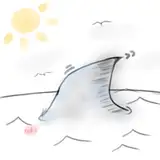
You see those red dots on the above map? Each of those is added by hand, needs to be as precise as possible, and has X and Y coordinates added manually. The process is called georeferencing (here's a tutorial as to how it's done). It’s very easy to make a mistake, such as enter 50 instead of -50 or leave out a 0, changing Longitude 40 to longitude 4. The problem is you don’t know if you’ve made a mistake until after you’re rendered the output, and more often than not I've ended up with the following:

The problem with that is each render takes about 30-minutes to finish, and 9 out of 10 times, once the render is finished it just shows you a major mistake that looks like a black hole in the middle of the map, like the one above.
When that happens, you just need to start from scratch plotting each point and rendering again. I’ve spent a good 25 - 30 hours this weekend making one such map, and I have 4 left to do...
To give you an idea of that the finished product looks like, here is the map before I run it through QGIS:

The above is the base map - I use this as the base for the atlas maps I publish - I crop, rotate and save a copy and use that as the base for the atlas maps. Look at the graticules - this map is clearly in a conic projection, which is useless for making a map that's focused on the equator.
To do that I need to convert this to an equirectangular map, which is what is shown below:

The landmass should be recognisable, though the farther north you get the more distorted and stretched outwards the map becomes. Compare the graticules from the earlier map to this one - the graticules in this once are all 1:1 ratio, which is what we want for an equirectangular map. I can use this and wrap it around a sphere to get a 3d image of the world (note that this map has the written coordinates, which i need for plotting the points, as shown in the first image in the post. also, the periphery of the land is unfinished - this is most evident in the east of the last map, beyond the mountains. This will be finished on the base map, in the conic projection, after which the map will be updated [once the georeferencing is done I save a file with with the points that can be used for undated maps. Unfortuantely every update takes about 30-minutes to render]).
Once I'm done converting all the continent maps that I have finished so far I'll be using this to make orthographic maps showing the world as it would appear zoomed in from space. This will be useful for many maps I plan on making, including:
I hope to make more maps that are centred around worldbuilding, hopefully bringing my patreon closer to its roots.
Only 4 maps left to do...
Nate Mangion
2019-08-22 15:06:27 +0000 UTCSteve Wood
2019-08-22 14:51:30 +0000 UTCNate Mangion
2019-08-22 14:44:38 +0000 UTCSteve Wood
2019-08-22 14:32:31 +0000 UTCNate Mangion
2019-08-22 14:23:54 +0000 UTCSteve Wood
2019-08-22 14:11:46 +0000 UTCNate Mangion
2019-08-22 13:41:23 +0000 UTCSteve Wood
2019-08-22 11:09:29 +0000 UTCNate Mangion
2019-08-22 10:55:09 +0000 UTCSteve Wood
2019-08-22 10:41:53 +0000 UTCNate Mangion
2019-08-22 10:17:33 +0000 UTCSteve Wood
2019-08-22 10:03:53 +0000 UTCNate Mangion
2019-08-22 09:43:03 +0000 UTCSteve Wood
2019-08-22 08:23:55 +0000 UTCNate Mangion
2019-08-19 04:02:16 +0000 UTCImpesio
2019-08-18 22:08:23 +0000 UTC