The Koutammakou landscape in northern Togo and Benin has the unusual distinction of being one of the few UNESCO world heritage sites that are known more to tourists than to historians of Africa. Towering above this undulating landscape are hundreds of fortified multi-story houses resembling small medieval castles built with coursed earth.
These monuments captured the imagination of later visitors to region, initially appearing among the drawings of Louis Binger in 1888 and the photographs of Leo Frobenius in 1907 —the latter of whom referred to their builders as 'the peasants of the castles.'
These castle builders are known as the Bètammaribè in Togo and Benin, while those seen by Binger were known as the Gurunsi/Kassena along the border between Ghana and Burkina Faso, where the palace of Tiebele was also elevated to the rank of a UNESCO world heritage site.
The history of these diverse communities, their links to the Mossi kingdoms, and the multiple functions of their distinctive monuments have unfortunately attracted little interest in African historiography, despite their contribution to the continent's diverse styles of pre-colonial architecture.
This article explores the function of these rural fortifications and the history of the Kassena and Bètammaribè communities that built these castles.

(left) Colorised drawing of Binger's engraving of a Gurunsi sacred building in Gourounga (right) a 'Somba castle' in Natitingou, ca. 1919, Benin. ANOM.

Concession of a Gurunsi chief, view of the interior taken from the terrace. ca. 1942, Burkina Faso, Quai Branly.

Map showing the main pre-colonial kingdoms (and ethnicities) mentioned in this text, the green squares are the kingdoms of Mossi, Dogomba, and Gourma, while the green circles are the fort builders; the Gurunsi/Kassena and the Somba/Bètammaribè
A History of the Kassena
The border region between northern-western Ghana and southern Burkina Faso is inhabited by diverse populations who speak the Gurunsi languages of the southern Gur group, among whom were the Kassena peoples.
Historically, the region consisted of small scale societies that were on the frontier of the larger polities such as the Mossi and the Dagomba kingdoms, to whom some of its chiefs occasionally paid tribute in exchange for protection, but otherwise remained mostly independent.

Map of Kassena country, showing the Gurunsi settlements visited by Binger (in red), the capital of the Zerma-Songhai warriors (in green), and the fortified royal compound of Tiebele (in blue)
By the middle of the 19th century however, the political-religious movements led by Fulani clerics that swept across west Africa eventually reached Kassena country in the form of migrant groups of Zerma-Songhay horsemen who had been displaced by the Fulani ascendancy. These Zerma horsemen were initially clients of the established elites, principally the kings of Dagomba, before they gained a large enough following to establish their own power in the region.
(Les dieux du territoire. Penser autrement la généalogie pg 58-59)
They set up their camps in western Kassena country (at Prata and Kasana, see map), recruited local allies, and launched devastating campaigns across the western parts of the Kassena region, to build up their followers and accumulate wealth. The names of their successive leaders --Alfa Hano, Alfa Gazare, Babatu - are still very present today in the memory of all these populations. Captain Louis Binger, who crossed this part of the Kasena country at the very time of the Zerma occupation (1887-1889), noted the existence of ruined settlements, but also mentioned that one settlement was spared because its chief submitted tribute to the Zerma, unlike his less fortunate neighbours who resisted.
To the east of the region, the chiefdoms of Tiébélé, Kaya, Po, Kampala, and others were also attacked by the Zerma, but much later (around 1890-1891) and more punctually. Some of these attacks were even partial failures for the Zerma, and the very strong resistance of the Nankana, immediate neighbors of the Kasena to the east, seems to have had the effect of quickly stopping the Zerma incursions into these regions, long before the arrival of French and British colonial armies in the region around 1897
(Les dieux du territoire. Penser autrement la généalogie. Pg 59-60)

Zerma-Songhai horseman in full costume, ca. 1924, Niger. archiviofotografico, societageografica.
The societies in the eastern Kassena region were relatively larger than their western counterparts, they all possessed distinct royal lineages that were of significant antiquity, and all of which recognized the seniority of the chief of Tiébélé.
According to historical traditions collected by Bernard Saint James (1972) the royal lineage of Tiébélé traces its origin to Mossi settlers, led by a founding figure known as Patouingomi or Buinkiete. This Mossi chieftain is thought to have come from Ouagadougou, accompanied by his supporters including a Fulani named Holo or Jolo who founded the settlement of Kaya. These migrations are traditionally dated to between the 16th and 17th centuries.
(Bonds and Boundaries in Northern Ghana pg 60-61, La cour royale de Tiébélé pg 7-10 )
The political and ritual primacy of the ruler of Tiébélé was such that the royal traditions of some of the neighboring settlements, such as Kaya, emphasize their origin and link to Tiébélé, inorder to indicate the link from where the chief currently draws the insignia of his power --a sacred royal object known as the Kwara. "Tiébélé is considered the eldest chieftaincy of Kaya and is responsible for enthroning the chief of Kaya".
(L’anthroponyme et le « récit étiologique » comme source de l’histoire des Kasena, Les dieux du territoire. Penser autrement la généalogie. Pg 169-170, 261-262)
The territory under the traditional authority of the Pé, the name given to the chief of Tiébélé, includes sixty-seven settlements. The Pé presides over all customary ceremonies and has decision-making power over important issues including conflict resolution. He is assisted by the district chiefs, the councillors, the elders of the princely lineages, the land chiefs, as well as by notables who act as intermediaries with the Chiefs of the villages dependent on Tiébélé.
In the courtyard, the Chief practices traditional religious rites, involving divination sessions to consult the ancestors and divinities of the Kassena pantheon. Offerings of sacrificial animals and agricultural products are typically made on specifically dedicated altars, visible in front of each main house
(La cour royale de Tiébélé pg 8-9, God and Sacrifice in the Traditional Religions pg 173-174)
The settlement at Tiébélé also lay along regional trade routes linking the Mossi polities to the north, with the kingdoms of Dagomba and Gonja to the south. Caravan merchants travelled south with cattle and shea butter, and some also carried Mossi cloth to exchange for sheep, kola nuts and salt from Daboya in the Gonja kingdom. The kassena region was also a major center of iron production.
(Brass-casting Among the Frafra of Northern Ghana pg 137)
Description of the fortified royal compound of Tiebele.
The Royal Court of Tiébélé constitutes an exceptional testimony of the historical traditions of the Kassena. Whether it is the architecture and decorations of the dwellings, the social organization of the chieftaincy or even the beliefs and religion, multiple aspects of the rich culture of this people have endured throughout the centuries.
Located at the foot of a hill in a plain landscape, the royal court of Tiébélé forms an irregular circular space of approximately 1.2 ha.


section of Tiebele.
The interior of the courtyard is divided into domains reserved for specific groups. Each section is composed of juxtaposed concessions, where the families live. The concession is composed of several structures connected by passages with low delimiting a certain number of courtyards.
Traditional Kassena housing is built entirely from local materials: earth, wood and straw. Most often, the structures have no foundations, and the tapering walls are built from shaped earth, although mud-bricks have recently been introduced.

interior of a Tiebele compound, Flickr image by Walter.

painted house at Tiebele, image by Giancarlo Carrara.

a painted Tiebele house, flickr image by meg_monica
The roof terrace was originally constructed as an independent floor whose beams supported by wooden pillars, all concealed with plaster, but more recent structures have it directly supported by the walls. This was accessed via a flight of stairs next to the house. The entire exterior was then extensively covered with various wall decorations using natural dyes, often by women, using motifs and patterns passed on through generations.
(La cour royale de Tiébélé pg 21-27)
Kassena architecture owes its complexity to the variety of compositions that can be created in a concession. These compositions enable the construction of numerous enclosed, semi-enclosed or open-air spaces, responding to the multiple social and spiritual uses specific to Kassena culture. The concessions are composed of structures that evolve according to changes in family size and organisation, which explains the presence of added constructions and the ruins of abandoned huts. This type of building tradition is therefore a dynamic form of architecture.
(La cour royale de Tiébélé pg 14)
Function of the Kassena Fortifications.
Multiple functions have been proposed for the construction of this form of 'defensive' architectural style, beginning with Louis Binger who passed near Tiebele in 1888. His account includes a description of the region's architecture and its relationship to the religious practices of the Gurunsi-Kassena:
"They have round earthen buildings, which are sacred; I have also seen them invoke God, who bears the same name as the sun [ouindï).
The sacred buildings, which affect almost all shapes and dimensions, are covered with geometric designs, circles, diamonds, squares, etc., painted with red or black ochre, or else variegated with gray obtained with the help of ashes diluted in water.
In Pakhé, one evening, while walking in front of one of these constructions, I had mechanically started to whistle. There you go, the village gathers and laments; I had just, it seems, profaned the holy places. I had to have it explained, for a good hour, that such an act committed by a European did not have at all the same significance as if it had been committed by a native."
(Du Niger au Golfe de Guinée par le pays de Kong et le Mossi)
The settlement of Pakhé mentioned by Binger is identified as Paga, a kassena site in Ghana just south from the border with Burkina Faso, and 18km south of another town he calls Poukha; which is identified as Pô in Burkina Faso. He also mentions the walled settlement of Koumbili which is 200km northeast of Po, and was sheltered in the walled town of Tiakane, 7km east of Po.
(Histoire du peuplement et relations interethniques au Burkina Faso pg 261-262, African Arts, Volume 16, University of California, pg 40, Burkina Faso: The Bradt Travel Guide pg 214)
While Binger was in the general Kassena area near Tiebele, few of the monuments he described survived, the only exceptionally well-preserved structures are those of Tiebele itself which provide the closest approximation to his illustrations, besides the more clear parallels with the 'Betammaribe castles' explored below. Despite his almost graphic description of the devastating camapiagns of the Zerma across the region, the Kassena structures that Binger described and drew had a mostly ideological/religious function rather than a defensive one.
However, this main function doesn't preclude the existence of alternative functions related to defense.
The royal court itself for example, is surrounded by high boundary walls connected to the walls of the dwellings, the whole forming an enclosure that is difficult to cross, with only one small gate as an entrance. The houses too are characterised by short door less than 1 meter tall, that is immediately followed by an interior wall inside the dimly lit interior.
(La cour royale de Tiébélé pg pg 16-17)
While none of these features would have posed a formidable obstacle to the cavalries of the Zerma, they would have provided sufficient defense against the much smaller and weaker forces of surrounding communities, in addition to enhancing the power of the chief.
A similar dynamic is observed further east in the Koutammakou landscape of northern Togo and Benin, home of the rural castles of west Africa.
A history of the Bètammaribè: "the peasants of the castles".
The northern region of Benin and Togo, whose landscape is dominated by the Atacora mountain range, is home to a diverse community known as the Bètammaribè.

Map showing the location of the Koutammakou landscape
According to ethnographer Jean Sulj, the name of this community; Batam-mariba community is an exonym derived from their distinctive 'castle-like' homes, and is translated as "great builders of tata". This diverse community, often called the 'Sombas' includes four ethnicities; the Tamberma of Togo, and the Bétiabé, the Besorabe, and the Bétammarié of Benin.
(Architecture et paysage Bétammaribé au Togo pg 80, Red Chalk Palimpsest: The Logic of Somba Landscape pg 194)
Like in Kassena territory, this region was also on the frontier of the larger kingdoms to its north and west such as the Mossi and the kingdom of Dagomba, and it too was comprised of small-scale societies organised around lineage groups.
Traditions about the emergence of the Bétammarié are associated with the Gourma kingdom, a small polity established in northern Togo in the 16th century, that owed its political structure to the Mossi kingdoms. Characterized by a low density, the Gourma country consisted of mostly autonomous chiefdoms that only nominally recognised the paramount at his capital Fada-N'gourma in Burkina Faso.
(Architecture, société et paysage Bétammaribé au Togo pg 86-88)
Its from this polity at Fada-N'gourma that the Bétammarié are said to have spread out across northern Togo and Benin, led by three ancestral figures, recalled as; N'poh, N'tcha and Kpakou. According to the ethnographer Leo Frobenius, who travelled through the region around 1907 and provided the first transcriptions of the Bétammarié's traditions, the group migrated from Mossi territory, to settle between the Kabyè, Losso and Lamba communities of Togo.
(La notion d’identité chez les Bétammaribé du Togo pg 77)
As for their linguistic classification, the Batammaribé are part of the Gourma group of the Oti-Volta subgroup in the northern Gur languages, while the Lamba, Losso and Kabye belong to the Gurunsi languages in the southern Gur group.
According to Frobenius, the Bétammaribé people called themselves bata-mawa, the singular of which is ota mado, which is translated as "the true mason". He thus called them the burgbauern: meaning 'the peasants of the castles' in German.
(La notion d’identité chez les Bétammaribé du Togo pg 77-78)

(left) A "Tata" residential house with some "Sombas". ca. 1925-1929, Natitingou, Benin, Quai Branly. (right) 'Sombas' in front of the entrance gate of the canton chief's concession, ca. 1945 - 1979. Benin. Quai Branly.
Description of the Rural Castles.
The main territory of the Bétammaribé is known as the Koutammakou/Kutɑmɑɑku and straddles the borders of Benin and Togo. It covers the modern districts of Boukombé and Natitingou in Benin, and the townships of Akpontè, Koutougou, Nadoba and Warengo in Togo. All over the region of about 5,000 km², there are fortress-houses or castles entirely built in clay with a rather particular engineering that stands out from those of most neighbouring communities.
(The Tata Tambera pg 262-263)

(left) Tata of the canton chief Bagedi. ca 1920-1944, Benin. (right) Somba village, ca. 1972-1973, Benin. Quai Branly.
 Somba dwelling of a canton chief, ca. 1900-1935, Benin. Quai Branly.

Tamberma farmstead. Phallic altars in front of the entrance. ca. 1907-1909. Togo. Frobenius Institute.
These structures, often referred to as 'Somba castles' or 'Somba tata' are more properly called the tèkyêntè.
The tèkyêntè are two story structures that rise up to three to five meters high. The structure is designed on a circular plan and is composed of an alternation of turrets with a round or oval base, connected to each other by curvilinear walls, which delimit a large room on the ground floor. The house has only one entrance, which allows good control and reinforces the defensive aspect. Depending on the case, this door gives access to the house through a first vestibule, but it can also be framed by two turrets topped with attics.
The ground floor (koudiégou) houses the interior altar of the ancestors (kouani-douoti), tools, a grinding room and the animals (cattle and poultry) that live in the rooms located at the bottom of the turrets. Access to the terrace is on the left side of the main door. Two sets of ladders link to an intermediate terrace, and the upper floor itself. The latter, known as the koudago, comprises the main living area with attics and rooms, It is also used for drying grains, preparing meals and all kinds of daily activities.
(Architecture et paysage bétammaribé pg 17-21, Architectural Self-Images of Africa's Taberma pg 380)

Ground floor plan, terrace level plan, and elevation. images by Thierry Joffroy et al.

Tamberma Tata Castle House, Togo. Flickr image by artagence.
As in the case of the Kassena, the Bétammaribé house is made of moulded earth and is not built on a foundation but on a flat ground, and is regularly maintained to ensure its structural integrity. The walls are also shaped by hand while the upper floors lay on horizontal beams which are supported by forked pillars of wood. The coatings are made with a sieved earth mortar that is kneaded with cow dung. The finish is made with a kind of whitewash prepared with a decoction of Néré bark, which gives a reddish-brown color to the tatas. This is done periodically as with the Kassena, and often by women.
(Architecture et paysage bétammaribé pg 28)

Function of the rural castles.
The authors of the above-cited article note that; with its turrets and high walls, the Bétammaribé dwelling has the appearence of a fortified farm similar to a west African 'tata' (see my previous article on Sudano-Sahelian architecture). European visitors to the region often compared these houses to fortified castles.
"But, if this form did indeed have a defensive role, perhaps even simply against wild animals, this is a very restrictive vision."
According to the research by the historian Paul Mercier and the architect Guy-Hermann, the tèkyêntè had a mostly ideological/religious function rather than a defensive function. They are differentiated, not by the existence or not of a ritual function within the family in which they participate and which is constituted around them, but rather by the degree of sacredness to which they are entitled, in view of the ancestral rules.
The structure is organised on two levels reflecting the Bétammaribé's cosmological concepts. the first level corresponds to the ground floor, and represents the basement which is the world of the dead, ancestors and spirits on the one hand. The upper floor corresponds to the world of the living, and represents the earth's surface on which human activities take place. To these two levels is added a third, made up of the different roofs of the dwelling, and which represents the sky.
The entire life of the Bétammaribé revolves around the tèkyêntè, from birth to death. The different rituals that punctuate the thread of the life of the individual, but also of the group, take place in and around the house, manifested by the existence in the house of altars dedicated to ancestors and divinities. The tèkyêntè could thus be the dwelling of the domestic group, or as a composite house occupied by all the descendants of the same ancestor, known as a kubwoti.
"This building plays a fairly important social role, insofar as it constitutes a pole around which both profane and sacred activities are structured and transmitted."
(La notion d’identité chez les Bétammaribé du Togo pg 83-88 , The Tata Tambera pg 266-269)

Tamberma adobe castles, Togo, image by Susan Carlslund. showing the ancestral altars.

Conclusion: multiple paths to monumentality in Africa's architectural history.
The history of Africa's 'defensive architecture' has, like most aspects of the continent's vast history, only recently gained mainstream academic interest and enabled us to highlight the rich cultural heritage of pre-colonial African societies. The Kassena and the Bétammaribé who constructed some of the continent's most distinctive monuments were largely isolated from the greater currents of West African history and lived in small-scale societies.
Their architecture challenges some of our preconceptions about Africa's past, such as the presumed links between complex societies and monumental architecture. In this case, fortifications and other defensive structures are typically associated with large cities and states like Meroe, Gondar, Harar, Kilwa and Segou.
The multiple functions of these rural 'forts' and 'castles' indicate that there were alternative paths to social complexity in Africa that existed beyond the often structuralist yet popular view of Africa's past which is more inclined towards the evolution of large centralized states and ignores the smaller, segmentary societies like those explored in this article.

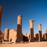
Soumba 'castles' in Natitingou, ca. 1919-1939, Benin. ANOM.
References:
Les dieux du territoire. Penser autrement la généalogie by Danouta Liberski-Bagnoud
Bonds and Boundaries in northern Ghana and Southern Burkina Faso by Sten Hagberg, Alexis Bekyane Tengan
Brass-casting Among the Frafra of Northern Ghana by Timothy F. Garrard
Histoire du peuplement et relations interethniques au Burkina Faso edited by Richard Kuba
African Arts, Volume 16, University of California
Burkina Faso: The Bradt Travel Guide By Katrina Manson, James Knight
Du Niger au Golfe de Guinée par le pays de Kong et le Mossi by Louis Gustave Binger
La cour royale de Tiébélé by Jean-Claude Dioma
L’anthroponyme et le « récit étiologique » comme source de l’histoire des Kasena by Ludovic O. kibora
Architecture et paysage bétammaribé by Thierry Joffroy et al
Red Chalk Palimpsest: The Logic of Somba Landscape by Fabrice Noukpakou et al.
La notion d’identité chez les Bétammaribé du Togo by Guy-Hermann Mawussé Padenou
The tata tamberma: a socioterminological study of the architecture of a people in togo and benin by Palakyem Mouzou
Houses Are Human: Architectural Self-Images of Africa's Tamberma by Suzanne Preston Blier
God and Sacrifice in the Traditional Religions of the Kasena and Dagaba of Northern Ghana by B. G. Der