Written in 1576, the chronicles of the kingdom of Bornu contain a curious account of an expedition conducted by King Idrīs Alooma beyond the southern banks of Lake Chad against a king of Wandara who had sought refuge in the mountain fortresses of northern Cameroon.
Beginning in 2002, archeologists started excavating a complex of stone platforms and terraces in the Mandara mountains of Cameroon whose construction was dated to between the 14th and 17th century.
Known as the DGB sites, the complexes were located close to the old capital of the Wandara kingdom and contained material evidence for links to the polities of the lake Chad region.
This article examines the history of the DGB sites of Cameroon within the context of the kingdom Mandara according to the 16th century chronicles of Bornu.


The DGB ruins in the political landscape of pre-colonial west africa.
Description of the stone ruins of Mandara.
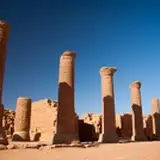
The DGB sites are 16 complexes of dry-stone terraces and platforms covering an area of 25km2 on the slopes of the northwestern extension of the Mandara Mountains in northern Cameroon. The acronym of DGB stands for ‘diy-ged-bay’, or ‘ruins of chiefly residence’ in the local Mafa language of the people who today reside next to them.
The sites were first described in the 1960s, as "ruins of fortifications" whose inhabitants attribute their construction to a semi-legendary group of builders that came before them. Extensive surveys and archeological digs undertaken during the early 2000s have since obtained radiocarbon dates for their construction as well as the material culture of the builders.
(Performance and Agency pg 4-5, 115-116)

the Mandara mountains

The DGB sites in the Mandara Mountains, Cameroon.
The most easily recognised characteristic used to identify DGB sites are the flat, carefully constructed dry-stone facades with plane faces of blocks laid in an approximation of coursing and rock wedges inserted to fill in interstices.
Common architectural features include staircases that offer access to platform tops, and passages that divide platforms into two or pass between them. Passages are walled in the manner of façades and in some cases are crossed or roofed with stone lintels. These are best attested at the sites of DGB-1 and DGB-2, which are the largest among the stone complexes, extending over 4 hectares and only separated by 100 meters. The other sites such as DGB-7 and DGB-8 feature well built facades like the first two sites but on a smaller scale, while the rest of the sites are relatively small ruins consisting of platforms, passages, terraces and collapsed walls.
(Performance and Agency pg 6-7, Monumental architecture in mountain landscapes pg 249-251)

View of some DGB sites (DGB-2).

DGB-10

Sketched reconstruction of DGB-8 
Plan of DGB-2 showing units excavated in 2002, surface and subsurface features.
DGB-1 and DGB-2 appear to have been built up over a long-term construction sequence, with multiple phases of construction associated with platforms, terraces and other features such as passageways, internal chambers, silos and courtyards. There's evidence for changes in the mode of access to different points of the site during different periods of occupation, with walls being built to close old passages, modify other passages into chambers, and enclose new platforms.
(Performance and Agency pg 37-43)
The Central Courtyard Area of DGB-1 includes evidence for food preparation and consumption in stone niches on the periphery of the sunken courtyard, burial of a cache of weapons underneath a floor in its northwest corner and the careful construction and then concealment of a stairway in the eastern wall of the courtyard. The practice of constructing stairways and passage at DGB-1, DGB-2 (and DGB-8), which would in later periods be infilled into a wall facades, suggests specific strategies for accessing the site that would evolve over time.
(Wandala and the DGB sites pg 279)

facade of DGB-1

Concealed stairway on the west side of DGB-1 
ceremonial walling of an abandoned Dughwede compound, DGB sites and the "Godaliy"
On the functions of the site, period of construction, and its settlers.
The variety of material culture recovered from excavations on DGB-1 and DGB-2 was predominatly local in origin, primarily consisting of ceramics that have some resemblance to modern Mafa ceramics, and the Wandala-speaking peoples of the Gwoza hills just north of the DGB sites. There were also small finds of glazed ceramics, glass beads, and a loop-in-loop metal chain that most likely originated outside the northern Mandara Mountains, as similar materials have only been found at the 18th century Wandala capital of Doulo.
(Performance and Agency pg 73- Wandala and the DGB sites pg 280)
Radiocarbon dating has provided approximately 20 dates from different parts of DGB-1 and DGB-2, establishing occupation between approximately 1350-1650 CE, while DGB-8, yielded three dates of the mid-15th century CE. The DGB sites appear to have had no defensive function since no protective walls are found atop their open platforms and terraces, they are frequently overlooked by neighboring physical features, and they have no protected access to water.
(Wandala and DGB sites pg 275, Power and Landscape in Atlantic Africa pg 319-321)

Iron braceletes with a loo-in-loop chain design, found near DGB-10.
With the exception of the facades, the architectural style of the DGB is mostly similar to that found in the modern northern Mandara landscape, a very densely populated region with up to 250 people/km2. A number of other archaeological sites with stone architecture have also been found along the foothills of the Mandara massif and on the inselbergs just to its north of the DGB sites, such as the village of Vreke, as well as the sites of Gre´a Tlala-Mafa and Garrvi Pulke 1.
(Wandala and the DGB sites pg 283)
Much of the northern and western region of Mandara mountains features impressive examples of stone architecture, especially in the agricultural terraces and homes such as in the Oujila area, in the south of Mora, around the DGB sites themselves, and the Sukur landscape in Nigeria. The terraces seen from below appear to form continuous dry-stone walls reaching to the heights of hills and crests, with homesteads of stone, daub and wood scattered among and around them.
(Monumental architecture in mountain landscapes pg 253-256)

mafa terraces

Terraces on satellite imagery around DGB-1/-2
The archeologist Nicholas David, whose 2008 publication provides the most detailed account of the DBG site archeology, suggested that the primary function of the DGB sites involved rituals associated with rain-making. He based this interpretation on specific artefacts and features found on the sites that would link them to such Mafa rituals, the lack of domestic contexts during initial excavations on DGB-2 and DGB-8, and the interpretation that the sites were built and occupied during a relatively brief period in the 15th century in response to droughts in the Lake Chad Basin.
(Performance and Agency pg 109-113)
However, the discovery of domestic features on the DGB-1 site during more recent digs by the archeologist Scott MacEachern, and the radiocarbon dates noted above that revealed a much longer settlement sequence, suggest a much complex history of site occupation and function. The recent excavations demonstrate that people lived at these sites and that some of them engaged in ritual activities (for example, involving the cooking of meat in a central courtyard of DGB- 1). They buried caches on both sites, and were engaged in building and remodeling its various architectural features over a long period of time.
(Wandala and the DGB sites pg 278-279, Monumental architecture in mountain landscapes pg 247)
The political history of the Wandala kingdom from the 14th to 17th centuries, and evidence from the Bornu chronicles.
The DGB sites in the political landscape of the lake Chad basin
The plains around the Mandara Mountains were within the orbit of multiple Islamic polities, such as the old empire of Bornu, the walled towns of Kotoko, the Sokoto caliphate, as well as smaller states and societies. However, it was the Wandala state which controlled the immediate hinterland of the DGB sites and the plains since atleast the 14th century. The population of the Wandala state speaks Chadic languages, and is culturally and linguistically similar to the montagnard populations living around the northwestern extremities of the Mandara Mountains such as the Mafa.
(Power and Landscape in Atlantic Africa pg 312)
The geographical and cultural dichotomy between mountains and plains in this area has been of central importance to the historiography of the local societies, existing in a mutually constitutive tension with one another. Although early scholars tended to exaggerate the dichotomy and attribute social complexity in the mountains to external impulses, such analysis has been revised in later studies as more recent research at sites like Zilum and the Kotoko polities uncovered new vectors of state formation and exchanges in the region.
(Wandala and the DGB sites pg 274, Power and Landscape in Atlantic Africa pg 314-318)
Written and oral traditions of the Wandala state place its origins directly to the north of the Mandara massif at its capital, Keroua/Kerewa, just under 30 km from the DGB sites. The traditions claim that the original inhabitants of the region were the Sao, a common ethnonym of semi-legendary autochthons that are associated with many pre-historic sites in the lake Chad region.
The Wandala kingdom and people, who are more commonly rendered in the Kanuri form ‘Mandera’/'Mandara', first enter written history in the mid-15th century in Fra Mauro’s mappamundo, produced in Venice, which places the kingdom next to the ‘Mergi’ (ie: Margi) and Bagirmi.
(Wandala and the DBG sites pg 274, 281,Power and Landscape in Atlantic Africa pg 314 )

detail of Fra Mauro's Map of the Lake Chad region (1450) , showing three ethnic groups in the Mandara mountains south of Lake Chad; the Margi, Bagirmi and Wandala.
The Wandala kingdom continues to appear in a variety of sources, especially the 16th century Bornu chronicles of the scholar Ibn Furtu, who was documenting the reign of his patron Mai Idris Alooma. Ibn Furtu identifies the Wandala capital at Keroua and its notes that Mai Idris was actively involved in the kingdom's internal politics and sucession struggles. These historical sources suggest that the rulers of Wandala were important political actors during the period between the 15th and 16th century, when we also see most evidence for occupation at the DGB sites.
The chronicle of the Bornu wars contains extensive references to the Mandara mountains which first appear as the refuge of a 'Sao'/'So' population that had originally inhabited the town of Tatala in the plains region. This group built a town but were later decimated by the Bornu forces.
(M.S. Page 27, The First twelve years of Mai Idris)
'Mandara' later re-appears as a kingdom ruled by a Sultan who had seized power from his nephew. The chronicler writes
"The deposed monarch came to the Sultan as a refuge seeking help and assistance from him against his wicked uncle, who had snatched away his kingdom. He was given a robe of honour, and regained his kingdom in accordance with his father’s expressed wish to the Sultan which was thus carried out after his death.
The origin of the affair, so we have heard, was as follows: The deposed king, who came to the Sultan for help, had been nominated by his father. The latter was afraid of his own brother and what he and his followers might do after his death. He was afraid that they would be unfaithful to him. The Sultan accepted the dying injunction of the king. So when matters turned out as was feared, and the deposed monarch came to him, the Sultan made preparation and went in person with his army to the city of Kerawa (Keroua).
When its inhabitants saw the Muslim host advancing by day, they fled defeated with their wicked king to the big wide hill, which is West of Kerawa, and climbed to the top, so that it was impossible for the Muslim army to attack them or get at them. So well fortified were they.
(M.S. Page 49, First twelve years of Mai Idris )
The Sultan returned home; but when the next year came round, he set out to catch the wicked one, he and his people. They found the Mandara people on the top of the rock as the first year. Then our Sultan Haj Idris formed a good and certain plan at a long spur of the hill which he invested, so that want and hunger overcame the enemy. They saw that the end was certain, so became afraid and came down from the top of the hill.
When they came to the place of audience, the Sultan’s heart relented and his wrath was appeased, since God had accomplished his purpose and showed him bounteous favour. The Muslims were delighted. The Sultan restored the deposed king to his throne.
(M.S. Page 50, The First twelve years of Mai Idris)
The 'land of Mandara' must have extended northwards significantly to the region of the Kotoko towns, as Bornu's armies are mentioned crossing the region to campaign against the town of Sabalgutu (M.S. Page 69, 70), the kingdom is neverthless noted as a separate entity whose 'Amir' was installed with Bornu's help after crushing "rebellions among his chiefs" (M.S. Page 71)

the Bornu empire at the time of Mai Idris Alooma.
Population movements in northern Mandara according to traditions of the Wandala kingdom and the Mafa people.
The account of Ibn Furtu highlights the role of mountains as a refuge during political conflicts and corroborates oral traditions regarding their use by populations in the plains when campaigns from Bornu reached the region.
It also indicates that there were significant political relationships between states in the region, as Bornu's involvement in Mandara sucession led to some Mandara princes being appointed in other regions it controlled. The brief mention of Mandara's trade in Iron to the Kotoko town of Quamaco, and then to Bornu in the 16th century account of Lorenzo of Anania also attests to such exchanges.
(Du Lac Tchad pg 122-126)
Traditions of the Wandala kingdom mention the arrival of several Kanuri groups from Bornu into the kingdom during the 17th and 18th centuries, where they settled in the towns of Bazza, Kerawa and Doulo. These movements were primarily driven by commercial factors, as well as a series of droughts in the lake chad basin, which is less agriculturally productive as the elevated regions of Mandara. While the kingdom campaigned against the mountain populations and also engaged in trade with them, the documentary evidence for such interactions is fragmentary before the kingdom's collapse at the turn of the 20th century.
(The Sultanate of Mandara to 1902 pg 114)
The Wandala maintained close relations with montagnard populations until the very end of kingdom's existence as an independent state, when members of the ruling family fled into the mountains south of their capital, Doulo, at the approach of Rabeh al-Zubar (the sudanese warlord who conquered Darfur and Bornu). Wandala military power was variably dependent on levies of montagnard bowmen in warfare on the plains, and there is abundant evidence for population flow and continuous cultural interactions between mountains and plains throughout Wandala history.
The close and continuing cultural interaction with the montagnard populations is made evident in non-elite Wandala material culture within the Wandala state, including at the capital of Doulo, where ceramics used by non-elite Wandala have been essentially indistinguishable from those used by neighbouring non-Wandala groups. However, historical evidence suggest that formal control over the mountainous regions was never fully attained even at the height of the kingdom during the 18th and 19th centuries, but power was instead negotiated through local systems of authority
(Ethnic Ambiguity and the African past pg 196-214)

Arrival at Mora, the capital of Mandara by British explorer Edward Francis Finden in 1826
In contrast to the Mandara people, the Mafa people who now occupy the area around the DGB sites first appear in written sources in the early 20th century, as Germany extended its colonial influence in the region. Their societies are often described as egalitarian, being governed by priest-chiefs and lineage heads.
The present populations of the Mafa don't claim to have constructed the sites, nor to be the original inhabitants, but respect them as evidences of power associated with predecessors in the region. Mafa traditions about the migration of some of their lineages into the DGB sites' region indicates that the original populations were acculturated.
(Performance and Agency pg 115-117)
David Nicholas suggests that a number of clan traditions of these present-day chiefly lineages of the Mafa recount two major phases of migration. The earliest phase of this migration is said to have suceeded the Godaliy who left the region before the Mafa arrived, and headed to the Gwoza hills. The latter region is presently occupied by speakers of the Wandala languages, and is located just between the northmost DGB site of Vreke and the Wandala capital of Kerewa.
He argues that the links between DGB and Gwoza would be consistent with the similarities noted between DGB material culture and that of the present peoples of the Gwoza hills, and concludes that "present evidence favors a Wandala linguistic group affiliation".
(Performance and Agency pg 118-119)

Mountain-edge site near Djibrile, between DGB-1/-2 and Keroua

the DGB sites and the location of the Wandala capital Ngoye Keroua
Unfortunately, the archeology of the early Wandala state is still in its infancy so links between the DGB site and the first Wandala capital of Keroua/Kerawa/Kirawa cannot be firmly established, but the site is known to contain tombs of the first Wandala kings and many settlement mounds. Limited test excavations identified the site of Ngoye Kirawa, which is a large (ca 750 m x 300 m) complex of terraces, walls, and house structures just to the northwest of the modern town of Kerawa/Kirawa.
(First twelve years of Mai Idris pg 171, Nyame Akuma Issue 041, pg 53)
The excavations indicate that terrace construction may have begun there between 78 -1020 CE, while surface survey around the inselberg located a variety of occupation mounds and other sites yielding ceramics that indicate occupation over the second millennium, including the Wandala period. The archaeology of the later Wandala capital at Doulo, about 30 km to the southeast, is rather better understood. The ceramic assemblages found on these plains sites are very similar to those made more recently by montagnards, indicating that these populations are archeologically similar.
(The Prehistory and Early History of the Northern Mandara Mountains pg 52-53, Wandala and the DGB sites pg 282)
Combining this evidence, Scott MacEachern thus argues that "the construction of DGB-1/-2 and the origins of the Wandala state around Keroua may thus be seen as parallel sociopolitical processes, occurring among a set of historically related but culturally diverging populations at a time of great political ferment".
(Wandala and the DGB sites pg 284)
Conclusions: the DGB sites at the frontier of west african archeology.
There is sufficient evidence for regional contacts and population movements between the DGB sites and the Mandara kingdom, making it probable that one of the ruins served as the refuge for the Wandara king who fled from Bornu's army in the 1576 account of Ibn Furtu.
While the sites themselves were not fortresses, it was the inability of Bornu's army to climb the mountains that gave its Wandala defenders an advantage, according to the chronicler. He attributes the eventual Bornu victory to a seige that forced the Wandala defenders to abandon the poorly provisioned region and submit. This is consistent with the observation that DGB sites are poorly defended and have no protected access to water, contrasted with fortified cities like Kano, that enclosed agricultural land and could withstand long sieges.
The re-discovery of the DGB sites thus represents an important milestone in the reconstruction of the region's history, and the emergence of complex societies in west Africa.

References.
Power and Landscape in Atlantic West Africa: Archaeological Perspectives edited by J. Cameron Monroe, Akinwumi Ogundiran
Performance and Agency: The DGB Sites of Northern Cameroon by Nicholas David
Ethnic Ambiguity and the African past edited by Francois G Richard, Kevin C MacDonald
History of the first twelve years of the reign of Mai Idris, Alooma of Bornu 1571 - 1583 by Aḥmad Ibn-Furṭū, Translated by H. R. Palmer
Du lac Tchad à La Mecque. Le sultanat du Borno et son monde by Rémi Dewière
The Sultanate of Mandara to 1902: History of the Evolution, Development and Collapse of a Central Sudanese Kingdom by Bawuro M. Barkindo
Wandala and the DGB sites: political centralisation and its alternatives north of the Mandara Mountains, Cameroon by Scott MacEachern
Monumental architecture in mountain landscapes: the diy-geδ-bay sites of northern Cameroon by Scott MacEachern & Nicholas David
Nyame Akuma Issue 041
The Prehistory and Early History of the Northern Mandara Mountains by Scott MacEachern