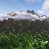
![Geotiff and Worldpainter data - Baden District, Austria - 1:1 scale [25k]](https://img5.xaiju.com/storage/5/qc/ul/d38796-019e83d9-259c-7756-98a4-1563d2e66f40.png)
Thank you for subscribing the Top Tier membership!
Here come the worldpainter project files and the raw tif data used to make the map of Baden District, Austria, at 1:1 scale [25k] , with buildings, roads, trees and other natural features derived from OpenStreetMap and GLC FCS 30 Land Cover data


The altitude of the terrain in the real world ranges from 164m to 834m asl
In Minecraft, the lowest point of the terrain on the map is at 164, while the highest point is at 834, with a vertical resolution of 1m.
Water level is at 0, while the maximum building height is 1024.
Map name: Baden District, Austria - 1:1 scale
Map size: 22226x29304
Map resolution: 1 block in the game corresponds to 1m in the real world
Map files size: - 14.4gb uncompressed, - 10.0gb compressed
Minecraft version: 1.18+
Bundesamt für Eich- und Vermessungswesen 1M DEM data for the Terrain Elevation
GLC FCS30 Land Cover at 30m resolution data for biomes positioning - cubic reinterpolation to 1m resolution
Open Street Map data for buildings, roads and any city element, trees, vegetation, waypoints, coastlines, rivers, streams and beaches positioning - rasterization to 1m resolution
WorldPainter .world files at 1m resolution: https://drive.google.com/file/d/1AW26yTItjc0mt3rr9MJ5o1KlodqiBUcq/view?usp=sharing
DEM data in Geotiff format at 1m resolution: https://drive.google.com/file/d/1pWdSIkxOB_siEkrV5a8q4QuOduEbp_l9/view?usp=sharing