Geotiff and Worldpainter data - St. George, Hurricane, Cedar City and Zion National Park (SW Utah, USA) - 1:3 scale - 46k
Added 2024-05-31 19:26:42 +0000 UTCThank you for subscribing Top Tier membership!
Here come the details of the data used to make the map of St. George, Hurricane, Ivins, Cedar City and Zion National Park (SW Utah, USA) - 1:3 scale - 46k
Map elevation and biomes images:


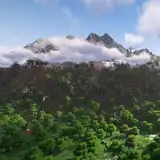
Various Zooms


The altitude of the map in the real world ranges from 669m to 3432m asl
In Minecraft, the lowest point on the map is at 285,while the highest point is at 1144, with a vertical resolution of 3m.
Water level is at 62, while building maximum height is 1536.
Map details:
Map name: St. George, Hurricane, Cedar City and Zion National Park (SW Utah, USA) - 1:3 scale
Map size: 48384x44288
Map resolution: 1 block in the game corresponds to 3m in the real world
Map files size: - 67.3gb uncompressed, - 49.5gb compressed
Minecraft version: 1.18+
Data used to process the map:
USGS 3DEP 1m and 3m DEM data for the Terrain Elevation - cubic reinterpolation to 3m resolution
NLCD 2018 Land Cover at 30m resolution data for biomes positioning - cubic reinterpolation to 3m resolution
Open Street Map data for cities, streets, waypoints, coastlines, rivers, streams and beaches positioning - rasterization to 3m resolution
Downloads:
WorldPainter .world file at 3m resolution:
https://drive.google.com/file/d/1iDA37i7jFK1DbYzN8aMIaBsvmZEf8VjN/view?usp=sharing
DEM data in Geotiff format at 3m resolution:
https://drive.google.com/file/d/1tRwqkF24a3_ZrEuM0dH7jASmmigMai5E/view?usp=sharing
NLCD 2018 Land cover data in Geotiff format at 30m resolution:
https://drive.google.com/file/d/1I8Nk7Dkhr7IR_lj4_S4ZdWz1dDfKkqGs/view?usp=sharing
OpenStreetMap Buildings Mask - Rasterization to 3m
https://drive.google.com/file/d/1v88QB67Slh0NT8gD3-KhtzNziYb1_c1t/view?usp=sharing
OpenStreetMap Roads Mask - Rasterization to 3m
https://drive.google.com/file/d/19fVgyzjMiRneQbkRQQzutn7UOlWaj2m0/view?usp=sharing